Advanced Search

Custom Search
Showing posts with label Lake. Show all posts

Monday, December 8, 2008

Toba Lake : One of the Largest Lake of the World

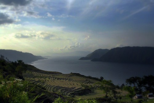
Toba Lake is the highest lake in the world, the largest lake in South East Asia, and also one of the most spectacular, surrounded by tall mountains and with a large Samosir Island in the middle of the lake, at an altitude of 1.000 meters. Toba Lake is 100 km long and 30 km wide, bigger than Singapore, formed by a gigantic volcanic eruption. it is probably the largest resurgent caldera on Earth.

Toba Lake is estimated that was formed during a volcanic eruption about 70.000-75.000 years ago and which was the most recent super volcano eruption. It is estimated that volcanic materials that were spewed out the mountain totaling 2800 cubic km, with 2,000 cubic km of ignimbrite that flowed over the ground and 800 cubic km volcanic ash that is estimated was blown (wind) to the west for 2 weeks. After this eruption, a caldera was formed that was filled by water afterwards and now known as Toba Lake. The pressure from the dormant magma, which has not yet erupted, caused Samosir Island to emerge. The region that now known as Samosir Island originally was a peninsula that attached to the Sumatra mainland.

Toba Lake lies in the Batak highlands, visited by both domestic and foreign tourist, and has become one of the main tourist attractions for a long time in North Sumatra apart from Bukit Lawang and Nias. It has a very enchanted scenery for being surrounded by green hills with steep, pine covered sloped. It offers beautifully magnificent view, fresh air, tranquillity, and pleasant. If visitors descend from the mountain they see the lake glittering in all its beauty.

The island in the middle of the lake - Samosir Island - was joined to the caldera wall by a narrow isthmus, which was cut through to enable boats to pass; a road bridge crosses the cutting. Tuk Tuk, named after the linguist Herman Neubronner van der Tuuk, is the main town to stay on Samosir Island. On the western side of the Samosir Island, just across the causeway from Pangururan, there are hot springs. In the Island, visitors can also find many big statues as Cemeteries for Batak people ancestors especially King Sidabutar's Graveyard, traditional houses of Batak Toba Samosir tribe, Batak museum with traditional dance performed in Simanindo, stone chairs used for judgement and executions in Ambarita, and see a waterfall up the hill around Tuk Tuk. In Samosir Island, there are two other lakes namely Lake Sidihoni and Lake Aek Natonang. Generally visitors go to Samosir Island by ferry from Parapat, a town on the side of Sumatra mainland.

Many types of flora live within the boundaries of Lake Toba, include various types of phytoplankton, emerged macrophytes, floating macrophytes, and submerged macrophytes. Lake Toba also offers a nurturing environment for fish such as the tilapia mossambica, aplocheilus pachax, lebistes reticulatus, osphronemus goramy, trichogaster trichopterus, channa striata, chana gachua, clarias batrachus, clarias nieuhofi, clarias. sp., nemachilus fasciatus, cyprinus carpio, puntius javanicus, puntius binotatus, osteochilus nasselti, lissochilus sp., labeobarbus sora, and rasbora sp.

Location of Destination
Lake Toba encompasses three districts, Simalungun, Parapat, and Ambarita districts. It lies about 176 km southwest Medan City, Capital of North Sumatra Province, Republic of Indonesia.

Route to Get Destination
By plane to Sukarno-Hata Airport (Jakarta). Then by domestic flight about 2 hours from Sukarno-Hatta Airport (Jakarta) to Polonia Airport (Medan).
Then by car approximately 4 hours from Polonia Airport (Medan) to Toba Lake. Or by train about 2 hours from Medan to Pematang Siantar town, then by car about 1 hour from Pematang Siantar to Toba Lake.

Best Time to Visit
May to August, or when there is event 'Toba Lake Traditional Party'

Accommodation for Traveller
Niagara Hotel, Panorama Hotel, Patra Jasa Hotel, Romlan Guesthouse (in Samosir Island), Tabo Cottages (in Samosir Island)

Sunday, November 30, 2008

Kelimutu : Mount with 3 Different-Colored Crater Lakes

The land of islands in Indonesia serves the travelers with the best of the landscapes to choose forms its vast menu. The land is blessed with numerous natural wonders ranging from the stretch of sandy beaches to the snow capped mountains. The land is blessed with some of the views of volcanic craters and the active volcanoes. Kelimutu Volcano is one of those which attract thousands of visitors to enjoy the impeccable beauty of the crater. Mount Kelimutu is a natural wonder and one of most mysterious and dramatic sights that can be found on top of this mountain. It has a unique and spectacular view on its three crater lakes with their respective colors. These colored lakes change colors on a regular basis. The latest colors (late 2004) were said to be turquoise, brown and black. The Lake on the western direction is called Tiwu Ata Mbupu (Lake of Old People) is commonly blue in color, the other two which share a common crater wall are Tiwu Nua Muri Kooh Tai (Lake of Young Men and Maidens) and Tiwu Ata Polo (Bewitched, or Enchanted Lake) commonly displays the green and red colors, respectively, although lake colors vary periodically.

Three crater lakes are located on the eastern summit of Kelimutu which is at an altitude of 1.631 meters. Each of the lakes has a distinctive physical structure, a unique geochemical and hydrothermal regime, and a particular historical sequence of color changes controlled by changes in physico-chemical conditions. The details of the lakes are:

Crater I : Tiwu Ata Mbupu (Lake of old people); 300 m x 280 m diameter; Depth 67 m; Blue color.
Tiwu Ata Mbupu, is the western-most lake. This crater is structurally different from the other two in that the pit crater it is in is itself located in the center of a larger crater. Small landslides constantly add to the steep rubble slopes along the lake's shore, and large boulders periodically drop into the lake. Shoreline of this crater is coated with a film colored in different shades of red, orange, and yellow depending on how thick it is. Gypsum crystals grow in the cracks of the crater wall in the first few meters above the prosent water surface.

Crater II : Tiwu Nua Muri Kooh Tai (Lake of young men and maiden); 430 m x 300 m diameter; Depth 127 m; Green color.
Tiwu Nua Muri Kooh Tai, is adjacent to Tiwu Ata Polo and is the deepest lake. Subaerial fumarolic or hydrothermal activity is implied by a large thermal plume in the center of the lake which slowly convects the water. A fresh supply of yellow froth (probably the same type of elemental sulfur found in the "cool acid-brine" crater lake at Kawa Ijen) is brought up by the plume and pushed out toward the crater wall. A particularly large cover of this froth has accumulated at the base of the north wall. During rainstorms the froth is scattered by inflowing water and landslides, though some of it may be disappearing altogether.

Crater III : Tiwu Ata Polo (Bewitched lake); 380 m x 280 m diameter; Depth 64 m; Red color.
Tiwu Ata Polo, lies on the southeastern side of the volcanic peak. A thermal plume in the northwest part of the lake indicates underlying subaerial fumarolic or hydrothermal activity. A white froth is present on the lake's surface around the plume when the convective activity momentarily increases. Rock debris is often carried into this crater during rainstorms by water draining the volcano summit around the lake. Two peaks abutting the crater rim help stabilize the east and northeast crater wall, while further around to the southeast a dip suggests a possible one-time overflow outlet. Such an outlet would have fed the river Ria Mbuli, whose upland source is in that area.

The visitors can enjoy the sight of active disturbance in the two eastern lakes mainly because of the sub aqueous fumaroles. These visitors in the past have even been enthralled by the minor eruptions from the volcano. Stationed on a 1639-meters-high Kelimutu volcano and a compound summit of 2 kilometers the Kelimutu Volcano is a beautiful treat to the eyes.

Types of fauna living around Kelimutu are deer (Cervus timorensis), pig forest (Sus sp.), red jungle fowl (gallus gallus) and hawk (Elanus sp.). Moreover, kinds of flora that can be found around Kelimutu are ‘Kesambi’ (Schleichera oleosa), casuarinas tree (Casuarina equisetifoia), and Edelweiss.

Location of Destination
Kelimutu is located 66 kilometers from Ende, Flores Island, East Nusa Tenggara Province (Lesser Sunda Islands), Republic of Indonesia.
(It is located on 8.75 S, 121.83 E to the equator).

Route to Get Destination
By plane to Sukarno-Hata Airport (Jakarta). Then by domestic flight about 2 hours and 20 minutes from Sukarno-Hatta Airport (Jakarta) – via Juanda Airport (Surabaya) – to El Tari Airport (Kupang, the capital of East Nusa Tenggara Province).
Then taking air transportation from El Tari Airport (Kupang), to Ende District approximately 40 minutes.
Then by public transportations to Kaonara Village, about 93 km away or 3 hours. Then by walk to the location for around 2,5 km.

Best Time to Visit
April to August

Accommodation for Traveller
Some lodgements are supporting facilities around the location. The surrounding village are also good places serving as bases for visits to Kelimutu, particularly those who wish to have a more leisurely pace and enjoy the views along the road between Ende and Maumere, or spend more time in Kelimutu.

Others
The villages around Mount Kelimutu are also known for their excellent weaving-all hand-made, still using natural dyes.

Travel Insurance